
Changelog
EVTools Product Updates
Keep track of your charging infrastructure usage
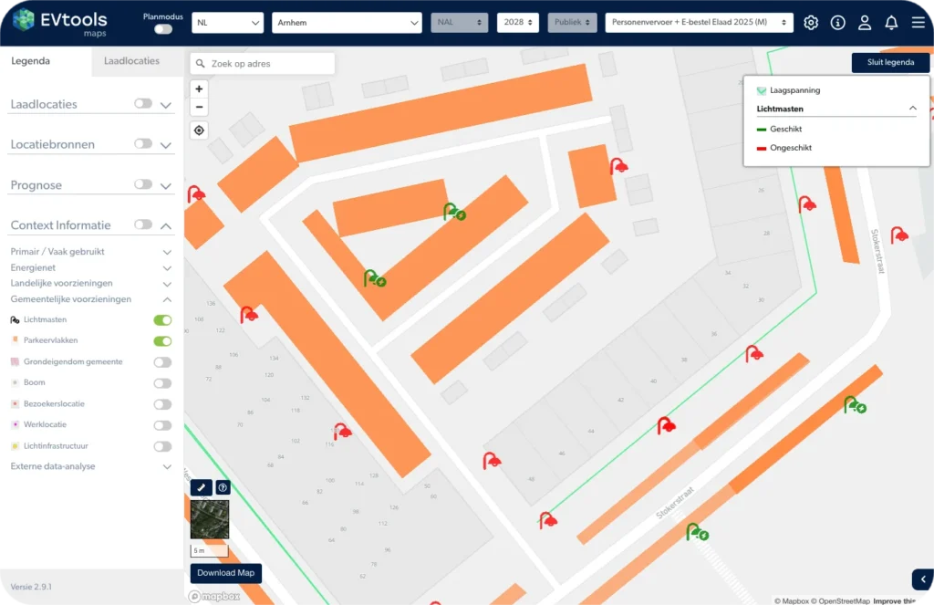
With the new map layer created by CityCharge, it’s clear at a glance which streetlights are suitable for charging infrastructure. The analysis shows that 12.5% of all streetlights are suitable. By integrating chargers into existing streetlights, public spaces aren’t cluttered with additional structures. This map layer is available for every municipality in the Netherlands. Thanks to the innovation clause, this approach can be implemented immediately within current concessions. Curious about the specific possibilities within a particular region?
Other developments
- EVMaps – Customized CPO dropdown list: The CPO dropdown has been improved: the most frequently used CPOs now appear at the top of the list. This makes selecting the desired CPO even faster and easier.
- EVMaps – Improved data quality: The logic for importing and saving charging locations has been updated. Thanks to this update, changes are processed more effectively, resulting in a clean map with fewer incorrect locations and duplicates.
- EVMaps – Expanded export fields: The export has been expanded to include the fields created_at and updated_at. This provides immediate insight into when a location was created and when it was last modified.
- EVMaps – Participation portal configurable by status: When configuring the participation portal, you can set whether residents can submit feedback based on the location’s status. Among other things, this allows you to collect feedback on locations with a “in preparation” status.
- Workflow – Export for all processes: A generic export function is now available that allows all different types of processes to be exported simultaneously into a single combined file.
- API & Workflow – UK requests processed: Applications from the United Kingdom are now processed correctly: addresses and ZIP codes are interpreted and stored correctly.
- Platform – Product updates are now available in the software: In both EV Maps and Workflow, you’ll find an overview of product updates under the rocket icon. We work in biweekly development sprints with continuous updates that you can view here.
EVTools Product Updates
Keep track of your charging infrastructure usage
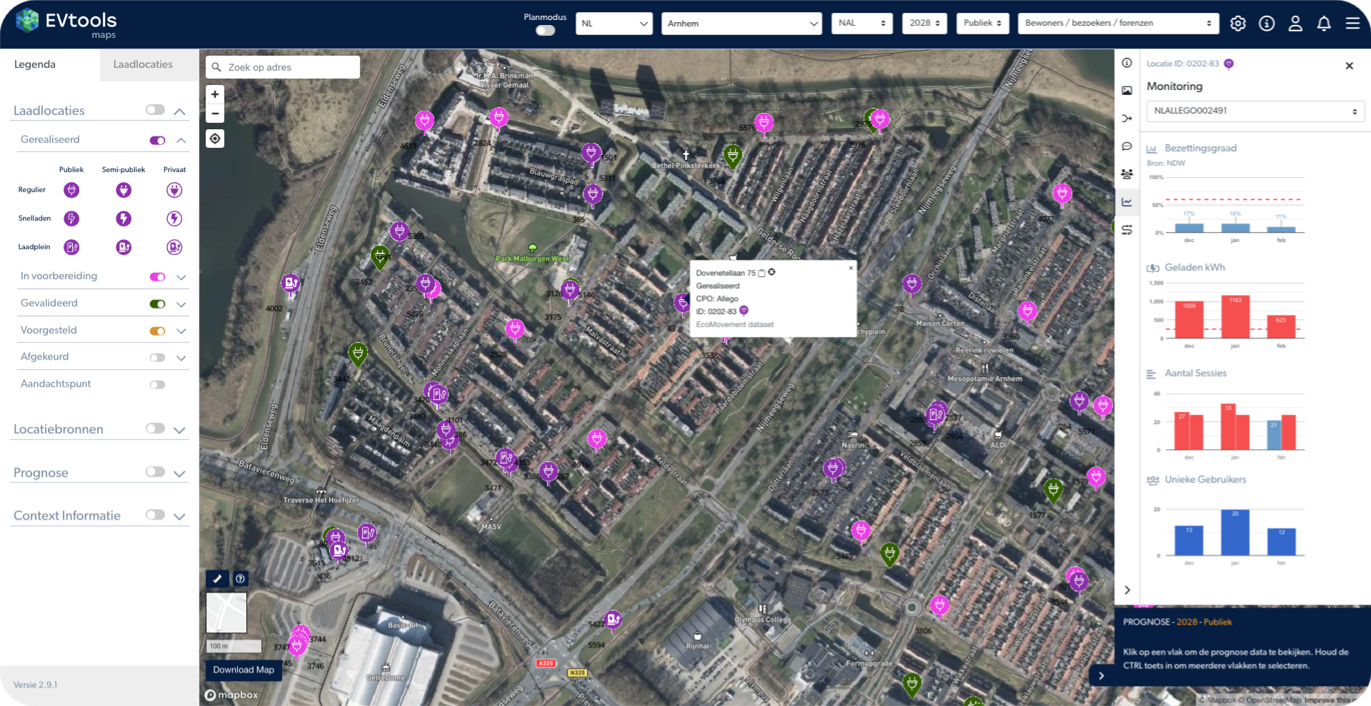
The accuracy of consumption data is essential for effective management. That is why we offer you various sources, with the Linda portal being displayed as a priority:
- LINDA data is displayed: consumption data from the LINDA portal takes precedence over other data sources.
- Flexible source selection: the source can be changed manually for each location, so that the desired source can be displayed.
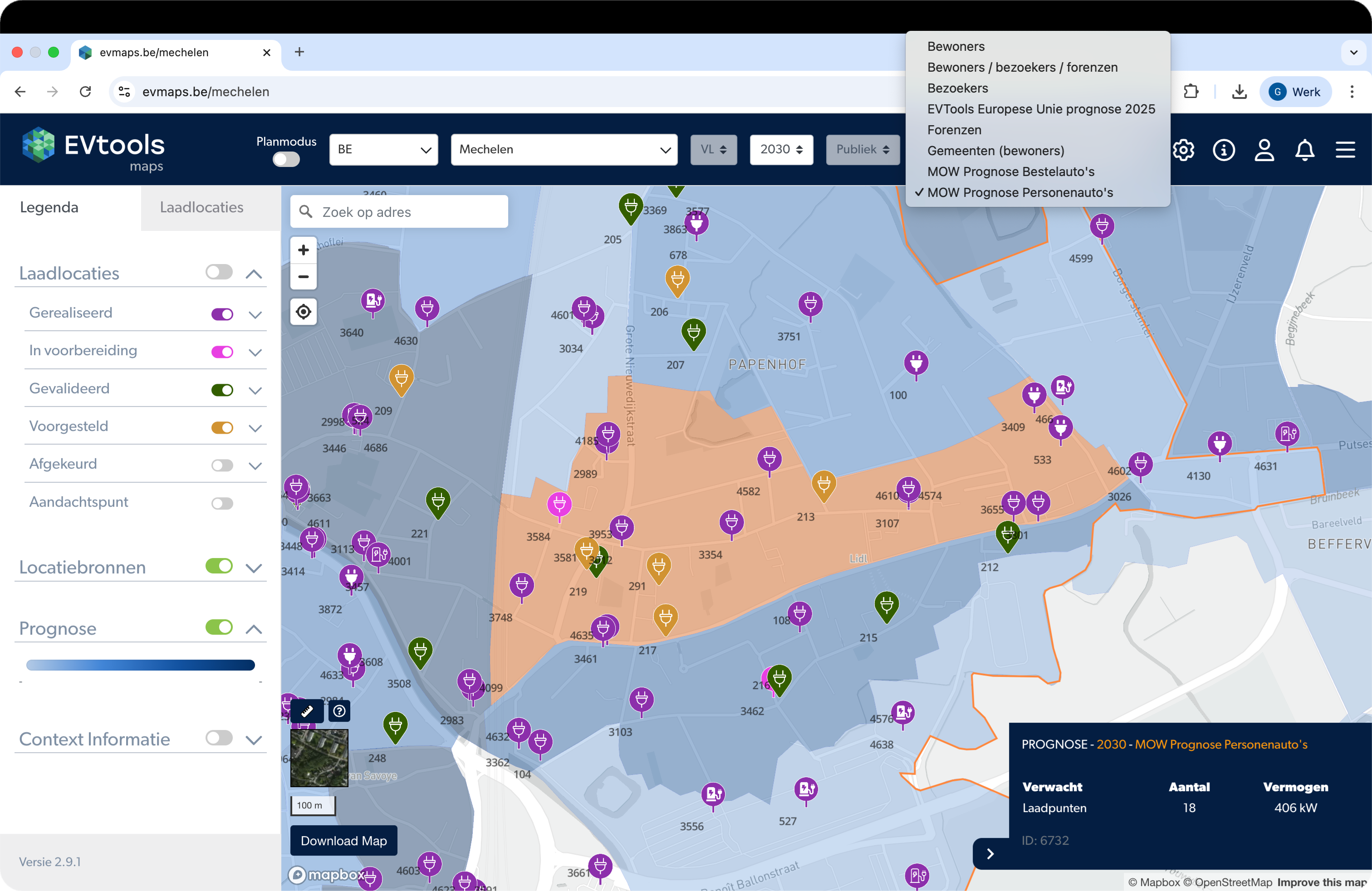
Forecast for Flanders up to 2028/2030 now available
Forecast maps at neighborhood level have been added for all Flemish cities and municipalities. These maps show the expected demand for charging infrastructure in 2028 and 2030, as drawn up by the Department of Mobility and Public Works (MOW). When a potential map is drawn up based on this forecast, you can be sure that your CPO has enough locations to realize.
Other developments
- EVMaps – Southwest Concession 2026: Locations planned in preparation for the upcoming South West concession have been (temporarily) assigned the fictitious CPO "Concession SW 2026" pending final award.
- EV Maps – Belgium Update: The map in EVMaps has been cleaned up for each municipality in preparation for the upcoming concession.
- Workflow – Automatic Start Document: A specific "Start Document" can now also be generated for the private process. This document is automatically created based on the fields filled in the Workflow. This document helps in collaboration with other parties such as the contractor.
- Workflow – UK Integration: The Workflow is now fully operational for use in all regions of the UK. Requests, locations, and processes can be processed and automatically synchronized with the EVMaps maps.
- Multilingual Website: The EVtools website is now fully available in German, French, and English. This allows us to make our expertise and solutions accessible to a broad group of European policymakers.
EVTools Product Updates
Combined forecast for passengers and freight transport
A combined forecast is now available that brings together the charging needs for both passenger transport and logistics, compiled by Elaad. The forecasted number of charging points is dynamically visible in the dashboard. This provides a complete and essential overview of the progress of electrification in your region. 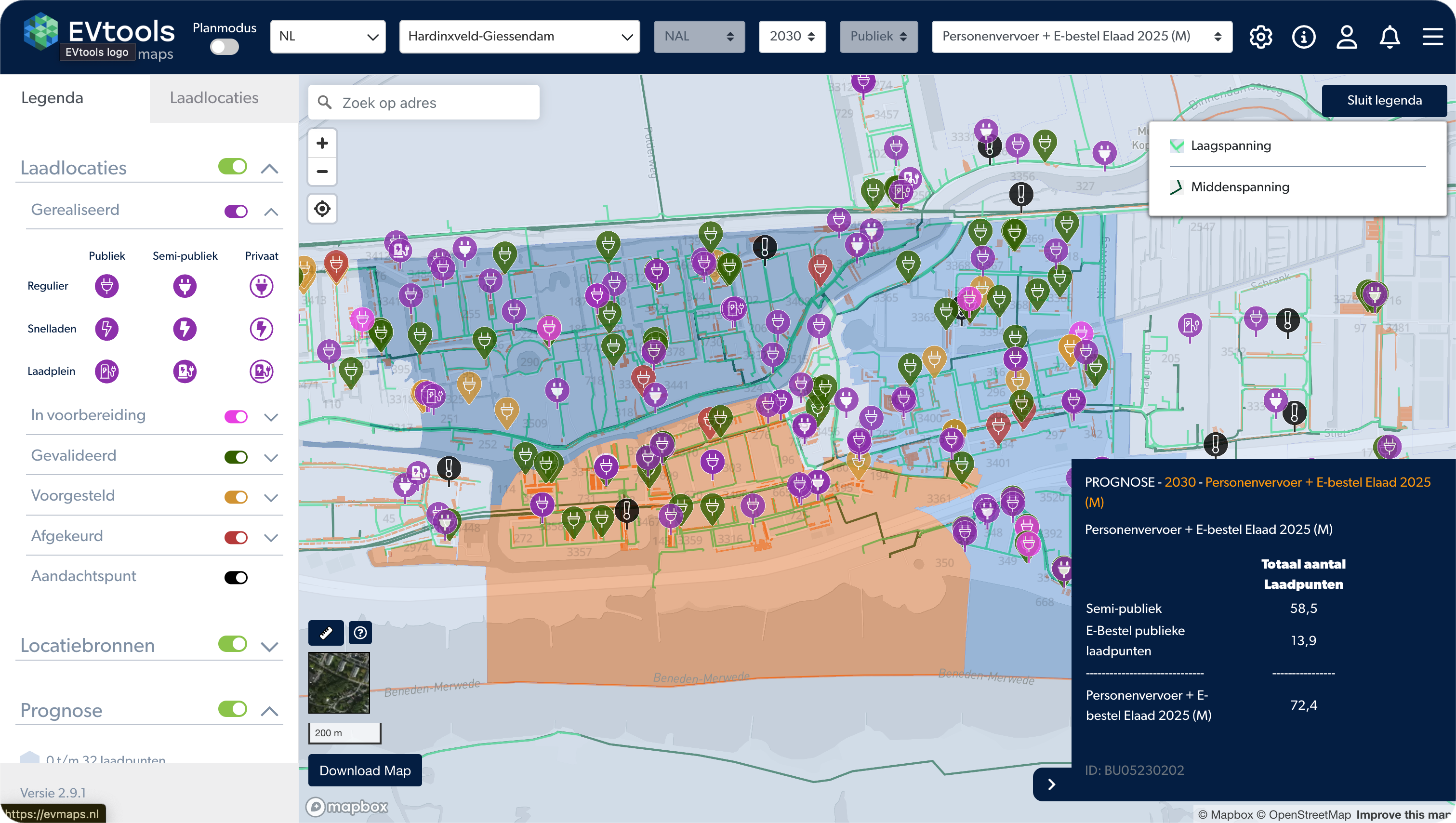
- EVMaps – Dynamic CPO filters The list of operators (CPOs) that you can filter on is now automatically updated based on the active parties in the selected region. This ensures that you always have an up-to-date overview of the relevant market players.
- EVMaps – Logging of location creation When loading locations are created via an external workflow, a comment is now automatically displayed in the log. This makes it clear who created a location, when, and why, which increases accountability.
- EVMaps – EU forecast optimized The model for charging demand within the EU has been visually optimized. This allows you to see at a glance where demand is greatest, simplifying strategic choices in international markets.
- EVMaps – 'Power' field added to export document When exporting locations, the 'power' field is now also included. This gives you direct access to all technical specifications for further analysis.
- Workflow – Faster map loading thanks to focus The map in the first step of the realization process has become faster. Only locations within your current zoom area are now loaded, which significantly improves performance in areas with a high density of charging points.
- API – Grid operator field modified To ensure data quality and consistency when exchanging data with network operators, the ‘grid operator’ field has been changed from a text field to a unique UUID.
EVTools Product Updates
Cyclomedia and EVMaps are now fully integrated
The link retrieves one top view and three side views per location from Cyclomedia. Since most municipalities and/or provinces already have an existing Cyclomedia account, use can begin immediately without any additional costs for EVTools administration.Please contact us if you would like to use this integration.

Other developments
EVMaps & Workflow Updates
- EVMaps – Automatic reduction of large images
EVMaps now allows you to upload images larger than 5 MB. EVMaps automatically reduces these to a more (technically) workable format without any significant loss of quality. - EVMaps – Automatic completion of CPO lists
The available CPOs in, for example, the filters and when creating new locations are now automatically supplemented with new CPOs on the market. This means you will never miss a CPO to choose from again. However, there are now so many CPOs that these options will soon be simplified for easier use. - EVMaps & Workflow – Multilingual support
EVMaps & Workflow are now available in Dutch, English, German, and French. You can set your preferred language in your profile settings. - Workflow – Direct access to EVMaps in step 1
In step 1, a direct link to EVMaps is now available, ensuring that all necessary geographic information is available when creating new locations. - Monitoring – KPIs over longer periods
It is now possible to select a range of several months. The KPIs are automatically calculated for the selected period. - Monitoring – Improved layout and expandability
The layout of the Monitoring app has been aligned with the Workflow reporting pages and offers expansion options for additional reporting pages.
In addition, various improvements have been implemented to further increase the scalability and robustness of the platform.
EVTools Product Updates
Charging points within walking distance for residents
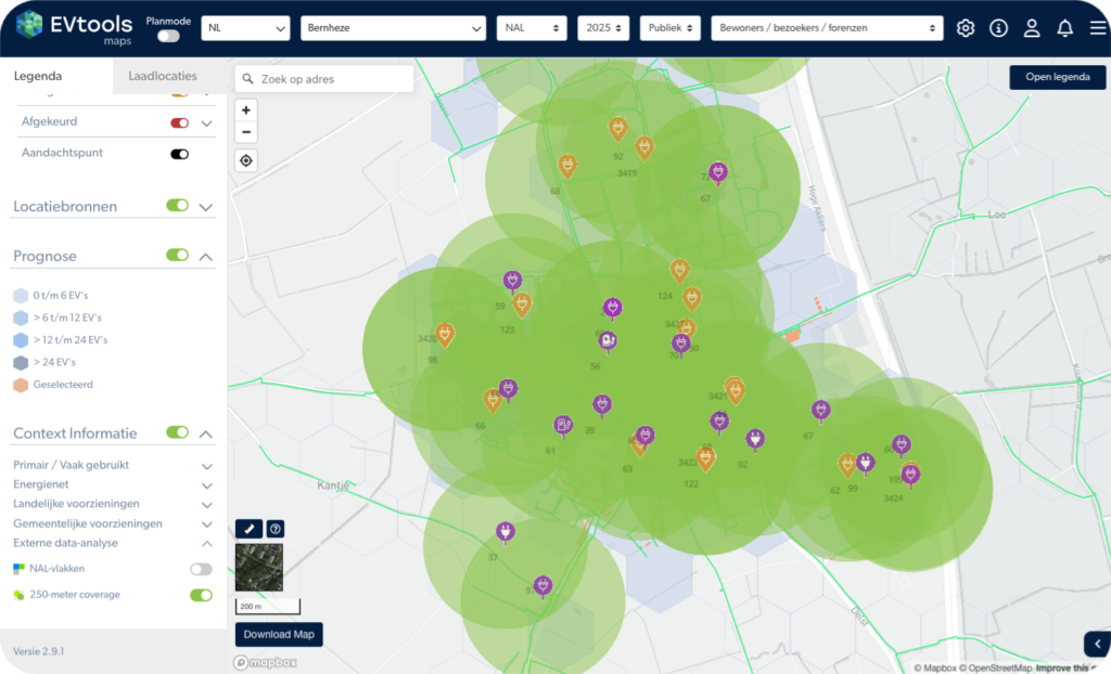
With EVMaps, you can now easily enable an interactive map layer with 250-meter circles. These circles instantly show which areas fall outside a 250-meter walking distance from a charging location. This allows you to easily ensure comprehensive charging network coverage. The 250-meter circle map layer is available internationally and is automatically updated with every newly planned location.You can activate the map layer via the Context Information menu under the tab External data analysis.
Easily integrate locations into your GIS system
The EVTools API now also supports the GeoJSON file type for retrieving locations. This significantly simplifies the direct linking of data to GIS systems such as ArcGIS or QGIS.
You can specify the desired data format as the query parameter format at the GET/chargingpoints/… endpoints.
More information and an example of retrieving locations in GeoJSON format can be found via the interactive API documentation.

Other developments
- EVMaps & API
It is now possible to save multiple top and side views for a location. This means that historical and additional views are also retained, providing a good picture of the location. It is also possible to indicate which images are marked as "primary." This allows third parties, such as the CPO and contractor, to know which images they can use. - Owner property for locations
Locations in EVMaps now have an additional Owner attribute (cf. OCPI). This makes it possible to indicate who the owner of a location is. - New CBS subraster map layer
New map layer CBS subrasters: In the provinces of North Brabant and Limburg, a new map layer has been added with CBS subrasters. This provides more detail and context for analyses within EVMaps. - Launch of EVMaps UK
Launch of EVMaps UK: EVMaps is now also available in the UK via www.evmaps.uk. - Workflow in English
In addition to EVMaps, Workflow is now also fully available in English. This makes the platform more accessible to international teams. You can easily set this up via the profile icon in the top right corner. - Workflow: clearing date fields
It is now possible to clear date fields within the Workflow. This provides greater flexibility when registering data. - Workflow: change process after cancellation
A change process can now also be restarted at locations where the previous process was canceled. This prevents locations from being unjustifiably "stuck" and makes the process more efficient. - Workflow: parking space numbers in removal process
When deleting locations, parking space numbers can now be added. This provides a more complete overview of the parking spaces used.
In addition, various improvements have been implemented to further enhance the scalability and robustness of the platform.
EVTools Product Updates
The EVtools API has been extended with 2 new endpoints, allowing locations to be retrieved in new ways.
- Locations within a bounding box -to be used when you want to define an area with 4 points and retrieve all charging points within it.
- Locations within a radius around a coordinate –perfect when you want to find all nearby charging points from a specific location (e.g., an address or GPS point).
Detailed information and an example on retrieving locations using this new method can be found on the
API documentation page: https://developer.evtools.nl/
Control over charging location visibility
- What is it?
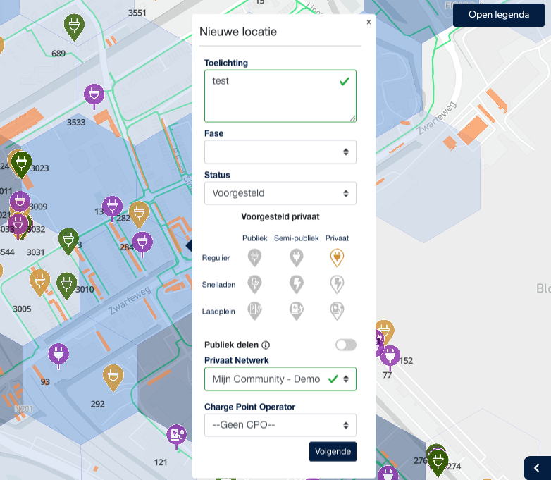
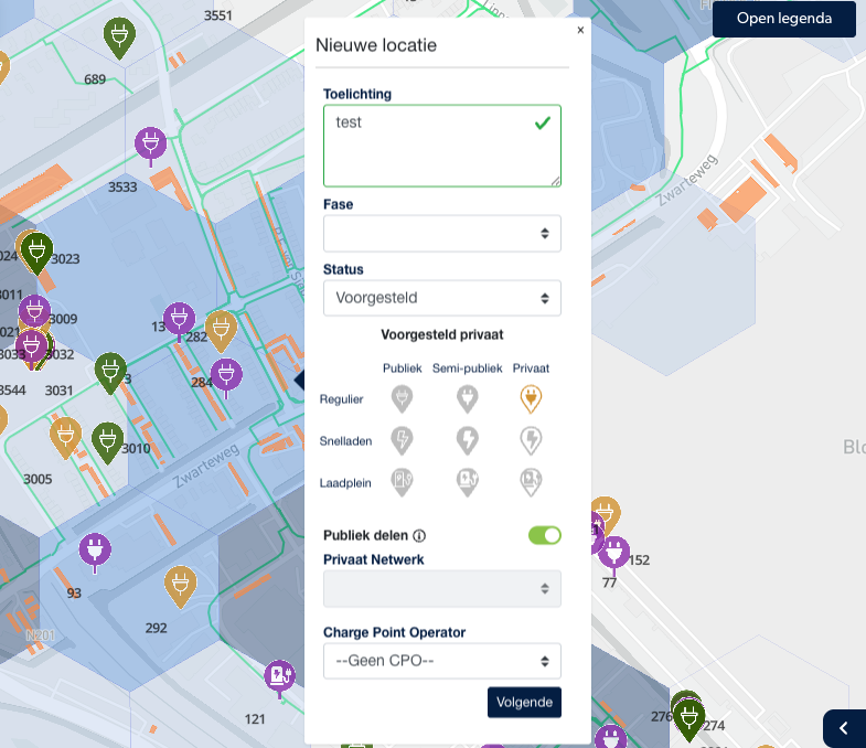
A new feature that allows you to determine whether charging locations are publicly visible or only shared within a protected network. Who is it for?
For managers of charging locations on private property, such as property managers, logistics companies, or public transport organizations that wish to grant selective access.Why is it useful?
You retain full control over the visibility of charging locations and can make them specifically available to partners or users, both in EV Maps and via the API (OCPI 2.3).
Changes to API endpoints in development environment
- API POST – and PUT/charging point endpoints have been adjusted in the development environment, see also www.developer.evtools.nl. The most important changes are:
- property “stakeholder” has been replaced by “cpo”
- property “owner” has been added.
- This adjustment will be implemented in production in week 41, so please adjust any implementations in time and contact us if you have any questions.
- These adjustments provide more information on the charging station in line with common protocols.

Other developments
- Map layers: The White Spots map layer has been updated. This allows the most up-to-date data to be used to determine in which regions it is necessary to install charging stations.
- Workflow: To provide more options for recording explanations about the delivery of a charging station in the Workflow, an additional comments field has been added in Step 8. This provides more space for context and explanations.
EVTools Product Updates
In EVtools, it is now possible to indicate for a charging location whether it may be publicly shared or not. This is particularly useful for charging locations on private property. You can thus determine whether the location becomes visible in external maps and apps.
When a location is created within a private domain in EV Maps, you can use the option “Public Sharing” to indicate whether it should also be visible to external parties. By external parties, we mean, for example, municipalities, grid operators, or navigation apps. By default, the public sharing function is enabled.
Sharing within a network
If a location may not appear on public maps and apps, there is still the option to share it with selected partners or specific users. This can be done by creating a network and adding charging locations to this network. Only users and externals with access to this network will see the location on the map.
If you would also like to create a network in EV Maps to add your charging stations to, feel free to let us know at support@evtools.nl. The network will then be created for you so you can share charging locations within that network as you see fit. There is no charge for this.
Practice application
Sharing locations in a protected network offers many opportunities, for example:
Property manager: make charging stations at different sites available only to own users.
Logistics entrepreneur: become part of a partner network to use each other's charging stations.
Public transportation organization: make charging infrastructure visible and usable only by other public transport companies.
CPO: implement charging stations for a specific carrier and gain insight into coverage, combined with public locations. This will help determine where expansion is needed.
Technical details
To enable this, the "publish" and "publish_allowed_to" attributes were added according to the OCPI 2.3 protocol (Section 8.3.1).
These attributes are part of the location location data and are also available in the API. In addition, a special endpoint is available to view the networks to which your API key has access: GET/private-networks.
Other developments
- Map layer: The CBS neighborhood map layer and the LS and MS grid map layers have been updated in EVMaps.
- Private Workflow: Mandatory fields are now set for this workflow so that data is entered more completely and consistently.
- Email workflow: If an email has not been sent, you can hover your mouse over the error message to immediately see the cause and a possible solution.
Frequently asked questions about our changelog
How often does EVTools release product updates?
EVTools publishes regular updates ranging from new features to data improvements, performance optimizations and platform enhancements.
Where can I follow the latest EVTools product updates?
Product updates are shared through the website, newsletters, release notes and the EVTools platform.
Are users automatically notified of new features?
Yes, users receive automatic notification of important updates, new modules and improved workflows.
How does EVTools determine which features will be developed?
New features are developed based on user feedback, market needs, policy guidelines and technology opportunities.
Are product updates included in my license?
Yes, all regular updates are included. Major extensions or optional modules can be purchased additionally.
Can I see what changes and improvements have been made in each update?
Yes, EVTools publishes a detailed changelog listing all new features, improvements, and bug fixes for each update. This way, you always stay up to date on what has changed in the platform.